Showing posts with label map. Show all posts

Thursday, November 29, 2018

Maps Give Detailed Look at Dramatic Land Use Change Over Two Decades - Yale E360


Landscape change between 1992 and 2015. White reflects little change. Darker shades reflect the greatest rate of change in each category. CREDIT: TOMASZ STEPINSKI/UC

A new map that stitches together 24 years of satellite observations provides a detailed look at striking changes in land use and widespread environmental degradation. According to the map, 22 percent of Earth’s habitable surface has been significantly altered since 1992, primarily from agricultural-driven deforestation.

“We already knew about deforestation or wetland loss or increasing urbanization,” said Tomasz Stepinski, a geographer at the University of Cincinnati and a co-author of the new map. “But now we can see exactly where all of that is happening… What makes this so depressing is that it’s examining a timescale that is shorter than our lifetime.”

The map illustrates widespread losses of wetlands in the Southeastern United States; the rapid disappearance of the Aral Sea, which “dried up in the 1990s after farmers in Kazakhstan and Uzbekistan diverted its tributaries for cotton fields,” a press release explained; deforestation in the tropics; and the expansion of the Sahara Desert…

more: Maps Give Detailed Look at Dramatic Land Use Change Over Two Decades - Yale E360


Wednesday, September 12, 2018

book :: Advice From a Geographer: Put Away the Map


Consider how strongly geography influences our deeper beliefs about the world, our notions of what is true and real.


In ‘Beyond the Map,’ Alastair Bonnett argues that when it comes to describing the world, lines and borders are hopelessly inadequate, even misleading.


OUR LIVES ARE saturated with maps. We see them in cars, subways, and airplanes. We access them with our phones, computers, and GPS devices. There are maps of deep space and of the topography of the deepest ocean floors. Then there are the maps of us — of our genomes, of the cognitive landscape of our brains, of the web of neural connections that allow us to see and think and act. Our faith in the map as a true representation of reality, and a reliable metaphor for experience and the concepts of modern life, is exercised every day, largely without question…

Advice From a Geographer: Put Away the Map


Wednesday, April 11, 2018

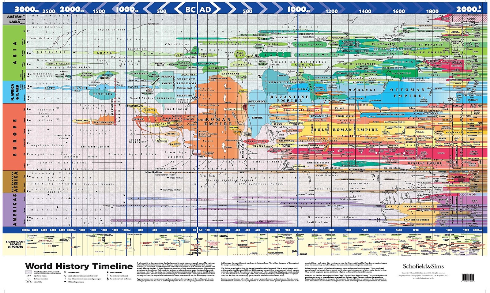
World History Timeline - Vivid Maps


“It is impossible to show everything that has happened in world history on a small poster. The main part of this Chart shows the rise and fall of the great empires and nations through history. It is arranged according to continents, and where possible continents that are next to each other on the globe are next to each other on the chart. It shows how people moved out of their homeland to conquer new territories, sometimes far from home. Each continent is shown in a limited color range, for example, Europe if red-orange-yellow. You can easily see when a European state took control of a country outside Europe because its color remains ‘European’ even though it is outside Europe. The length of the color shows the length of time the empire lasted and the width shows how extensive was the territory they controlled…"

more: World History Timeline - Vivid Maps


Friday, May 15, 2015

Medicinal Plants - old US map


"Medicinal Plant Map of the United States of America." Edwin Newcomb and the National Wholesale Druggists' Association, 1932.


This map of medicinal plants depicts one or two important species that grew in each state in 1932, identifying the plant as native or cultivated and describing its medical uses. A few species of seaweeds float in the map's Atlantic Ocean, and the border identifies important medicinal plants from around the world... 


History of medicinal plants: Map of the plants in the United States from 1932.